You Won’t Believe What Lies Beneath Hamburg’s Streets
Hamburg isn’t just canals and fish markets—there’s a whole hidden world beneath your feet. I never expected to find underground rivers, abandoned bunkers, and sunken train lines while exploring the city. This is a side of Hamburg most tourists miss. The city’s special terrain—shaped by floods, war, and centuries of urban engineering—tells a story you can actually walk through. Come with me as we dive into the real underground Hamburg.
The City Built on Water and Mud
Hamburg is not built on solid ground. Beneath its cobblestone streets and elegant buildings lies a fragile foundation of silt, clay, and peat—remnants of ancient marshlands shaped by the Elbe River and its many tributaries. Over 2,000 years ago, early settlers chose this location for its access to trade routes, unaware of the challenges posed by such a waterlogged environment. Today, much of the city sits less than five meters above sea level, making it one of Europe’s most vulnerable urban areas to flooding and subsidence. Engineers have long understood that stability here requires constant intervention, which is why Hamburg’s development has always been a delicate dance between human ambition and natural forces.
To support its infrastructure, the city relies on an intricate system of wooden pilings, concrete slabs, and deep foundation techniques. In some areas, buildings rest on thousands of pine and oak piles driven deep into the soft soil until they reach firmer layers below. Remarkably, many of these wooden supports remain intact after centuries—preserved by the lack of oxygen in the wet ground. However, when exposed to air during construction or excavation, they can deteriorate rapidly, posing risks to older structures. This hidden foundation network is invisible to most residents, yet it plays a crucial role in keeping homes, offices, and historic landmarks standing upright.
The city’s relationship with water extends beyond structural concerns. Hamburg’s layout has been shaped by the need to manage constant moisture. From the earliest dykes built in the 12th century to modern pumping stations and stormwater retention basins, water control has dictated where neighborhoods could grow and how streets were aligned. Even today, urban planners must account for rising groundwater levels, especially during periods of heavy rainfall or high tides. As climate change increases the frequency of extreme weather, Hamburg’s underground infrastructure faces new pressures. The city’s surface may appear stable, but beneath it, a quiet battle against water continues every day.
Understanding Hamburg’s geological reality helps explain why so much of its history lies underground. What appears to be solid land is often the result of centuries of land reclamation, landfill, and engineering. Entire districts, such as HafenCity, have been constructed on artificially raised ground using millions of tons of imported soil and gravel. These efforts have allowed the city to expand, but they also create complex subsurface conditions where old waterways, forgotten tunnels, and buried foundations coexist. This layered terrain offers a unique window into how cities adapt to their environments—slowly, deliberately, and often invisibly.
Floods That Changed Everything
No event in Hamburg’s modern history has had a greater impact on its underground landscape than the North Sea flood of 1962. On the night of February 16, a powerful storm surge overwhelmed the city’s coastal defenses, sending seawater rushing into low-lying neighborhoods. Over 300 people lost their lives, thousands were displaced, and entire districts—including Wilhelmsburg and Veddel—were submerged under several meters of water. The disaster exposed the fragility of Hamburg’s relationship with the Elbe River and marked a turning point in how the city approached flood protection and urban planning.
In the aftermath, Hamburg launched an ambitious program to strengthen its defenses. Massive flood barriers were constructed along the riverbanks, including reinforced dykes, movable storm gates, and elevated roadways. One of the most significant changes was the redesign of street levels in vulnerable areas—many roads were raised by up to two meters, creating a stepped urban landscape where sidewalks now sit noticeably higher than nearby buildings. This shift altered the city’s topography in subtle but lasting ways, contributing to the complex network of underpasses, retaining walls, and drainage systems that exist today.
Survivor accounts from the 1962 flood describe scenes of chaos and resilience—families fleeing to upper floors, neighbors rescuing each other by boat, and entire communities coming together in the days that followed. These stories remain part of Hamburg’s collective memory and continue to influence public policy. The city now operates a sophisticated early warning system, with real-time water level monitoring and automated alerts sent to residents in at-risk zones. Moreover, new construction projects are required to incorporate flood-resistant designs, such as waterproof basements, elevated electrical systems, and permeable surfaces that allow water to drain naturally.
The legacy of the 1962 flood is not just visible in infrastructure—it’s embedded in the city’s mindset. Hamburg has shifted from trying to control water to learning how to live with it. This philosophy is evident in recent urban developments that integrate green spaces, retention ponds, and open plazas designed to absorb excess water during storms. By acknowledging its vulnerability, the city has become a leader in climate-resilient urban design. The flood may have been a tragedy, but it also sparked a transformation that continues to shape Hamburg’s underground and surface worlds alike.
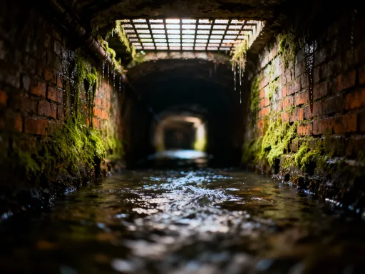
Secret Tunnels and Forgotten Passages
Beneath Hamburg’s bustling streets lies a labyrinth of tunnels, passageways, and disused transit lines—many of which are unknown to the average resident. These subterranean corridors were not built for public use but for utility, defense, or transportation purposes that have since faded into history. Some stretch beneath major landmarks like the Hauptbahnhof (central station), while others wind under the Alster lakes, connecting forgotten parts of the city. Though largely inaccessible today, these spaces offer a glimpse into Hamburg’s layered evolution and the hidden systems that once kept it functioning.
One of the most extensive tunnel networks dates back to World War II, when the city constructed air raid shelters and emergency escape routes. Many of these were built beneath public buildings, train stations, and housing complexes, designed to protect civilians during Allied bombings. Some tunnels were later repurposed for storage, telecommunications, or maintenance access, while others were simply sealed off and abandoned. Over time, they became part of the city’s forgotten infrastructure—dark, damp, and slowly being reclaimed by nature. Despite their neglect, these spaces remain structurally sound in many areas, a testament to the durability of mid-20th-century engineering.
Another category of underground passages includes remnants of Hamburg’s evolving public transit system. In the early 20th century, plans were drawn up for additional U-Bahn (subway) lines that were never completed due to war, budget constraints, or shifting priorities. Sections of tunnel were excavated but never connected to the main network, leaving behind ghost stations and dead-end corridors. Some of these spaces have been explored by urban adventurers, though entry is strictly prohibited due to safety regulations. Unauthorized access can lead to fines or even criminal charges, as the tunnels may contain unstable structures, poor air quality, or active utility lines.
Despite the risks, there is growing interest in repurposing these forgotten spaces. In recent years, artists and cultural organizations have collaborated with city authorities to transform select tunnels into exhibition spaces, performance venues, or sound installations. These projects aim to reconnect the public with Hamburg’s hidden history while ensuring safety and preservation. For example, temporary art displays have been installed in disused subway tunnels during cultural festivals, allowing visitors to experience the city’s underground in a controlled and legal way. These initiatives reflect a broader trend of reimagining urban infrastructure—not just as functional systems, but as part of the city’s cultural identity.
The Underground River System
Long before Hamburg became a major European port, a network of small rivers and streams flowed freely across the landscape. These waterways—such as the Tarpenbek, Schlump, and Eißendorfer Bach—fed into the Alster and Elbe, shaping the region’s ecology and influencing early settlement patterns. As the city expanded during the 19th and early 20th centuries, many of these natural streams were channelized, covered over, or redirected into underground conduits to make way for roads, railways, and buildings. Today, they continue to flow beneath the city, hidden from view but still very much alive.
The burial of these rivers was part of a broader urbanization trend seen in many European cities. At the time, covering waterways was considered a modern solution to sanitation, flood control, and land use efficiency. Open streams were seen as breeding grounds for disease and obstacles to development. However, this approach came at an environmental cost. By disconnecting the city from its natural hydrology, Hamburg lost valuable green corridors, reduced biodiversity, and increased surface runoff during heavy rains. In recent decades, urban planners and environmentalists have begun to reconsider this legacy, advocating for the daylighting—uncovering—of buried streams as part of sustainable city design.
One of the most promising projects is the re-naturalization of sections of the Tarpenbek stream in the Eimsbüttel district. Here, city officials have removed concrete linings, restored natural banks, and created green pathways along the water’s edge. The result is not only a more attractive public space but also improved water quality, better flood management, and enhanced habitats for birds, insects, and amphibians. Similar efforts are underway along parts of the Alster, where former industrial zones are being transformed into ecological buffer zones that allow the river to meander naturally.
For curious visitors, there are subtle signs of Hamburg’s buried rivers. Manhole covers marked with fish symbols, sudden drops in terrain, or patches of unusually lush vegetation can indicate the presence of underground water. Some access points, such as maintenance shafts or overflow chambers, allow glimpses of the flowing streams below. While direct entry is not permitted for safety reasons, guided ecological walks and educational programs offer insight into this hidden hydrological network. These experiences help foster a deeper appreciation for the city’s natural foundations and the importance of integrating water into urban life in a sustainable way.
Bunkers You Can Walk Inside
Rising from the cityscape like concrete monoliths, Hamburg’s WWII-era bunkers are among the most visible remnants of its wartime past. Constructed between 1940 and 1943, these massive structures were designed to withstand aerial bombardment and house thousands of civilians during air raids. The most famous example is the Flakturm in St. Pauli, a towering anti-aircraft fortress with walls up to 3.5 meters thick. Though no longer used for military purposes, these bunkers remain deeply embedded in the city’s underground fabric—both physically and symbolically.
Due to their immense size and reinforced construction, many bunkers could not be demolished after the war. Instead, they were repurposed for various uses. The Flakturm, for instance, now serves as a climate-controlled archive and event space, hosting concerts, exhibitions, and even a small museum dedicated to its history. Other bunkers have been converted into indoor climbing facilities, storage centers, or emergency shelters. Their deep foundations and sealed interiors make them ideal for temperature-sensitive applications, and some are being studied for potential use in future climate adaptation strategies, such as heat-resistant refuges during extreme summer temperatures.
What makes these bunkers particularly fascinating is their dual nature—they are both historical artifacts and functional infrastructure. Visitors can tour select facilities through official guided programs, where historians explain their construction, wartime role, and postwar transformation. These tours often include access to underground levels, ventilation shafts, and former living quarters, offering a tangible connection to the past. The experience is sobering yet educational, emphasizing resilience, survival, and the long-term consequences of conflict.
Today, the bunkers also serve as reminders of the importance of preparedness. With increasing concerns about climate change and extreme weather events, Hamburg is revisiting the idea of using robust underground structures for public safety. Unlike temporary shelters, these bunkers offer long-term protection from floods, storms, and heatwaves. As the city continues to grow and face new environmental challenges, the lessons learned from these wartime structures may prove more relevant than ever. They stand not just as relics, but as enduring symbols of strength and adaptability.
Modern Engineering Beneath the Surface
While Hamburg’s historical underground structures capture the imagination, the city’s modern engineering feats are equally impressive—though far less visible. Beneath its streets lies a vast network of tunnels, pipelines, and support systems that keep the city functioning. The Elbe Tunnel, opened in 1975 and expanded in 2019, allows vehicles to pass beneath the river, connecting key commercial districts. Its construction required advanced tunneling techniques, including pressurized shield boring to prevent water ingress in the soft riverbed. Similarly, the U-Bahn subway system operates through a complex web of deep-level tunnels that must be constantly monitored for stability.
One of the biggest challenges engineers face is Hamburg’s high water table. Because the city sits so close to sea level, groundwater often seeps into excavations, making construction difficult and expensive. To counter this, builders use methods such as grouting—injecting liquid cement into the soil to solidify it—and sheet piling, where interlocking steel walls are driven into the ground to create watertight barriers. In large-scale projects, such as the construction of underground parking garages or building basements, dewatering systems are installed to pump out groundwater continuously during excavation. These measures ensure that foundations remain dry and stable, even in the wettest conditions.
Real-time monitoring plays a crucial role in maintaining underground safety. Sensors embedded in tunnels, bridges, and building foundations track movement, moisture levels, and structural stress. Data is transmitted to central control centers, where engineers can respond quickly to any signs of instability. For example, if a section of tunnel begins to shift due to soil erosion, automated alerts trigger inspections and preventive repairs. This proactive approach minimizes disruptions and enhances public safety, allowing the city to grow without compromising its fragile terrain.
These engineering solutions are not just technical achievements—they reflect a deeper philosophy of coexistence with nature. Rather than attempting to conquer the environment, Hamburg’s infrastructure works with it, adapting to seasonal changes, tidal patterns, and long-term climate trends. This mindset is evident in the city’s commitment to sustainability, from green roofs that reduce runoff to permeable pavements that allow water to recharge the groundwater supply. By investing in smart, resilient design, Hamburg ensures that its underground systems will support future generations.
How to Explore Hamburg’s Hidden Terrain (Safely)
While much of Hamburg’s underground world remains off-limits for safety and security reasons, there are legitimate and enriching ways to experience its hidden layers. The key is to go through official channels that prioritize preservation, education, and public access. Guided tours offer the safest and most informative way to explore restricted areas, led by experts who understand the historical, environmental, and engineering significance of what lies beneath. These programs are designed with families and curious travelers in mind, making them accessible to adults and older children alike.
One of the most popular destinations is the Kehrwieder Bunker, located near the historic warehouse district. This WWII-era shelter has been partially restored and opened for guided visits, where guests can walk through original corridors, see reconstructed living spaces, and learn about daily life during the war. The tour includes multimedia displays and archival footage, providing context without sensationalism. Another recommended site is the Flussbad Ochsenwerder project, an ecological restoration initiative that allows visitors to see how buried streams are being revived. Interpretive signs and walking paths make it easy to understand the science behind re-naturalization efforts.
For those interested in urban hydrology, the Alster River trails offer scenic walks along re-naturalized sections where the water flows freely. Information panels explain the history of the river, its burial and recovery, and the species that now thrive in its restored habitats. These green corridors are not only beautiful but also functional, serving as natural flood buffers and wildlife corridors. Comfortable walking shoes, weather-appropriate clothing, and a reusable water bottle are recommended for these outings. Families will appreciate the accessibility of these routes, many of which are stroller-friendly and include rest areas.
To plan a visit, it’s best to consult the official Hamburg tourism website or contact local cultural organizations that organize underground tours. Advance booking is often required, especially for bunker visits and special exhibitions. Participants should follow all safety guidelines, stay with the group, and avoid touching surfaces or entering restricted zones. Photography is usually permitted for personal use, but drones and flash photography may be prohibited. By respecting these rules, visitors contribute to the preservation of Hamburg’s hidden heritage while gaining a deeper understanding of the city’s resilience and innovation.
Hamburg’s true character isn’t just in its skyline or harbor—it’s beneath your feet. The city’s special terrain tells a story of resilience, adaptation, and quiet innovation. By understanding its hidden layers, visitors gain a deeper connection to one of Europe’s most dynamic urban landscapes. The next time you walk through the city, remember: there’s always more beneath the surface.